
Alerheim topographic map
Click on the map to display elevation.
About this map
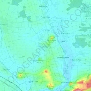
Name: Alerheim topographic map, elevation, terrain.
Average elevation: 1,378 ft
Minimum elevation: 1,325 ft
Maximum elevation: 1,699 ft
Other topographic maps
Click on a map to view its topography, its elevation and its terrain.
Nördlinger Ries
Deutschland > Bayern > Landkreis Donau-Ries > Nördlingen > Pfäfflingen
Das Nördlinger Ries ist nahezu kreisrund (Durchmesser etwa 20 bis 24 Kilometer). Die Flächenausdehnung beträgt 348 km². Der Krater ist aufgrund seiner Größe und der starken Verwitterung nur aus der Luft deutlich zu erkennen. Vom Boden aus erscheint der Kraterrand als eine bewaldete Hügelkette ringsum am…
Average elevation: 1,385 ft
Niederhofen
Deutschland > Bayern > Landkreis Donau-Ries > Oettingen i.Bay. > Niederhofen
Average elevation: 1,516 ft
Gansheim
Deutschland > Bayern > Landkreis Donau-Ries
Gansheim liegt im Usseltal am östlichen Ende des Landkreises Donau-Ries auf einer Höhe von 429 m über NN. Die nächstgelegene Stadt ist Rain am Lech, die ca. 10 km weiter südlich liegt. Die Große Kreisstadt Donauwörth liegt ca. 14 km westlich.
Average elevation: 1,555 ft
Oberndorf am Lech
Deutschland > Bayern > Landkreis Donau-Ries > Oberndorf a.Lech
Average elevation: 1,332 ft
Holheim
Deutschland > Bayern > Landkreis Donau-Ries > Nördlingen
Das Pfarrdorf hat 405 Einwohner (Stand: 3. Januar 2022). Es liegt auf einer Höhe von 456 m ü. NN am Rand des Nördlinger Rieses, knapp 4 km südwestlich von Nördlingen.
Average elevation: 1,552 ft
Großsorheim
Deutschland > Bayern > Landkreis Donau-Ries > Harburg (Schwaben)
Average elevation: 1,519 ft
Belzheim
Deutschland > Bayern > Landkreis Donau-Ries > Ehingen a.Ries > Belzheim
Average elevation: 1,480 ft
Klostermühle
Deutschland > Bayern > Landkreis Donau-Ries > Utzwingen > Klostermühle
Average elevation: 1,447 ft
Schloß Alerheim
Deutschland > Bayern > Landkreis Donau-Ries > Alerheim > Schloss
Schloss Alerheim, auch Burgruine Alerheim genannt, ist die Ruine einer Höhenburg zusammen mit neueren Gebäuden im Weiler Schloßruine der Gemeinde Alerheim im schwäbischen Landkreis Donau-Ries in Bayern. Es liegt auf einem Hügel, dem „Schlossberg“, bei 455,4 m ü. NHN im Westen des Ortes.
Average elevation: 1,391 ft
Schwörsheim
Deutschland > Bayern > Landkreis Donau-Ries
Auch der Zeitpunkt der Ortsgründung des zugehörigen Weilers Haid ist unbekannt. Die erste sichere Erwähnung aus dem Jahr 1307 gibt keinen Aufschluss über die Entstehungszeit. Es ist anzunehmen, dass Haid mit seinem topographischen Ortsnamen (Heide) im 9. Jahrhundert als Ausbauort von Megesheim entstanden ist.
Average elevation: 1,365 ft