
Make a donation
Gear up for your next adventure:
As an Amazon Associate, this site earns from qualifying purchases at no extra cost to you.
Roy topographic map
Click on the map to display elevation.
Make a donation
Gear up for your next adventure:
As an Amazon Associate, this site earns from qualifying purchases at no extra cost to you.
About this map
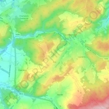
Name: Roy topographic map, elevation, terrain.
Location: Roy, Marche-en-Famenne, Luxembourg, Wallonie, 6900, Belgique (50.15733 5.37790 50.22750 5.47315)
Average elevation: 1,122 ft
Minimum elevation: 787 ft
Maximum elevation: 1,634 ft
Make a donation
Gear up for your next adventure:
As an Amazon Associate, this site earns from qualifying purchases at no extra cost to you.
Other topographic maps
Click on a map to view its topography, its elevation and its terrain.
Verdenne
Belgique > Luxembourg > Marche-en-Famenne > Marche-en-Famenne
Localité se trouvant à la limite de la bande calcaire de la Calestienne et du massif ardennais, Verdenne est situé à une altitude d'environ 300 m à environ 5 km à l'est du centre de Marche-en-Famenne. Il est traversé par le petit ruisseau de Woizin qui disparaît dans un chantoir à l'entrée de…
Average elevation: 942 ft
Marche-en-Famenne
Belgique > Luxembourg > Marche-en-Famenne > Marche-en-Famenne
Average elevation: 827 ft
Champlon-Famenne
Belgique > Luxembourg > Marche-en-Famenne > Marche-en-Famenne
Champlon-Famenne se trouve à la limite de la bande calcaire de la Calestienne et de l'Ardenne. Le village s'étire principalement le long d'une rue en côte (rue de la Forêt) où les habitations se situent à une altitude allant de 275 m à 350 m. Champlon se trouve à environ 4 km au sud-est du centre de…
Average elevation: 1,010 ft
Make a donation
Gear up for your next adventure:
As an Amazon Associate, this site earns from qualifying purchases at no extra cost to you.
Grimbiémont
Belgique > Luxembourg > Marche-en-Famenne > Marche-en-Famenne
Grimbiémont est situé à environ 6,5 km au sud-est de Marche-en-Famenne à une altitude comprise entre 300 et 380 m.
Average elevation: 1,148 ft