
Make a donation
Gear up for your next adventure:
As an Amazon Associate, this site earns from qualifying purchases at no extra cost to you.
Champlon-Famenne topographic map
Click on the map to display elevation.
Make a donation
Gear up for your next adventure:
As an Amazon Associate, this site earns from qualifying purchases at no extra cost to you.
Champlon-Famenne
Champlon-Famenne se trouve à la limite de la bande calcaire de la Calestienne et de l'Ardenne. Le village s'étire principalement le long d'une rue en côte (rue de la Forêt) où les habitations se situent à une altitude allant de 275 m à 350 m. Champlon se trouve à environ 4 km au sud-est du centre de Marche-en-Famenne en amont du vallon du Fond des Vaulx dans un environnement de prairies presque entièrement entourées d'importants massifs boisés
Make a donation
Gear up for your next adventure:
As an Amazon Associate, this site earns from qualifying purchases at no extra cost to you.
About this map
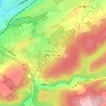
Name: Champlon-Famenne topographic map, elevation, terrain.
Average elevation: 1,010 ft
Minimum elevation: 650 ft
Maximum elevation: 1,335 ft
Make a donation
Gear up for your next adventure:
As an Amazon Associate, this site earns from qualifying purchases at no extra cost to you.
Other topographic maps
Click on a map to view its topography, its elevation and its terrain.
Make a donation
Gear up for your next adventure:
As an Amazon Associate, this site earns from qualifying purchases at no extra cost to you.
Make a donation
Gear up for your next adventure:
As an Amazon Associate, this site earns from qualifying purchases at no extra cost to you.