Geolocate

Hillham topographic map

Click on the map to display elevation.

About this map

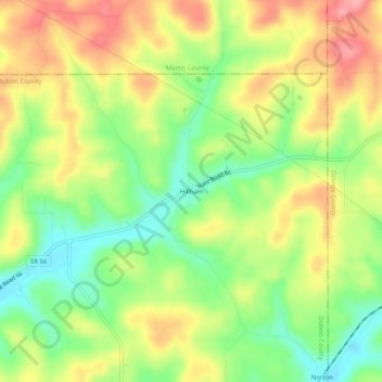
Name: Hillham topographic map, elevation, terrain.

Location: Hillham, Dubois County, Indiana, United States (38.49394 -86.72055 38.53394 -86.68055)

Average elevation: 682 ft

Minimum elevation: 515 ft

Maximum elevation: 856 ft

Dubois County trails, hiking, mountain biking, running and outdoor activities

Other topographic maps

Click on a map to view its topography, its elevation and its terrain.

Birdseye

United States > Indiana > Dubois County

Average elevation: 669 ft

Jasper

United States > Indiana > Dubois County > Jasper

Average elevation: 495 ft

Holland

United States > Indiana > Dubois County

Average elevation: 509 ft

Gear up for your next adventure:

👟Men's Trail Runners - Lightweight footwear for fast-paced exploration and light hiking
🪶Thermal Camp Blanket - Extra warmth for cold nights
🎒Outdoor Daypacks - Lightweight backpacks designed for carrying maps and essential gear
🧭GPS Watch Accessories - Bands and chargers for GPS watches
🏥Hiking First Aid Kits - Comprehensive medical kits for remote trail injuries

As an Amazon Associate, this site earns from qualifying purchases at no extra cost to you.