
Make a donation
Gear up for your next adventure:
As an Amazon Associate, this site earns from qualifying purchases at no extra cost to you.
Yushu topographic map
Click on the map to display elevation.
Make a donation
Gear up for your next adventure:
As an Amazon Associate, this site earns from qualifying purchases at no extra cost to you.
Yushu
With elevations above 3,600 metres (12,000 ft), the prefecture has a harsh climate, with long, cold winters, and short, rainy, and cool to warm summers. Specifically, in the Köppen system, the prefecture ranges from the alpine variation of the subarctic climate (Köppen Dwc), to a full alpine climate (Köppen EH), to a semi-arid climate (Köppen BSk). Most of the annual precipitation occurs from June to September, when on average, a majority of the days each month has some rainfall. The annual mean temperature in Yushu County, at an elevation of 3,690 metres (12,110 ft), is 3.22 °C (37.8 °F) and in Qumarlêb, in the northeast of the prefecture at 4,190 m (13,750 ft) elevation, −2.13 °C (28.2 °F). Sunshine is generous, ranging from around 2500 hours in the prefecture seat to 2780 hours in Qumarlêb.
Make a donation
Gear up for your next adventure:
As an Amazon Associate, this site earns from qualifying purchases at no extra cost to you.
About this map
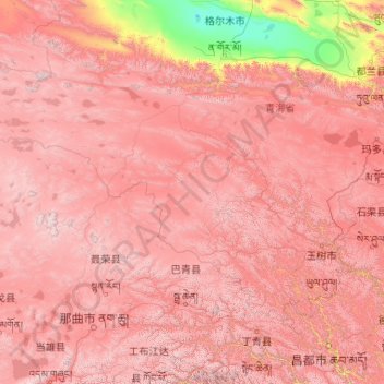
Name: Yushu topographic map, elevation, terrain.
Location: Yushu, Qinghai, China (31.60180 89.40222 36.28011 97.75823)
Average elevation: 14,672 ft
Minimum elevation: 8,786 ft
Maximum elevation: 21,447 ft
Make a donation
Gear up for your next adventure:
As an Amazon Associate, this site earns from qualifying purchases at no extra cost to you.
Other topographic maps
Click on a map to view its topography, its elevation and its terrain.
Xining
China > Qinghai > Renminjie Subdistrict
The city was a commercial hub along the Northern Silk Road's Hexi Corridor for over 2000 years, and was a stronghold of the Han, Sui, Tang, and Song dynasties' resistance against nomadic attacks from the west. Although long a part of Gansu province, Xining was added to Qinghai in 1928. Xining holds sites of…
Average elevation: 8,219 ft
Qaidam Basin
China > Qinghai > Da Qaidam Administrative Zone > Qaidam
Orographically, the Qaidam Basin is a comparatively low area in the northeastern part of the Tibetan Plateau. With an elevation of around 3,000 m (10,000 ft), Qaidam forms a kind of shelf between Tibet to the south (around 4,300 m or 14,000 ft) and Gansu to the north (around 1,100 m or 3,500 ft). A low water…
Average elevation: 8,996 ft
Make a donation
Gear up for your next adventure:
As an Amazon Associate, this site earns from qualifying purchases at no extra cost to you.
Make a donation
Gear up for your next adventure:
As an Amazon Associate, this site earns from qualifying purchases at no extra cost to you.
Make a donation
Gear up for your next adventure:
As an Amazon Associate, this site earns from qualifying purchases at no extra cost to you.
Make a donation
Gear up for your next adventure:
As an Amazon Associate, this site earns from qualifying purchases at no extra cost to you.
Golog Tibetan Autonomous Prefecture
China > Qinghai > Gadê County
The lay of the land of the prefecture is largely determined by the Amne Machin mountain range (max elevation 6,282 m), which runs in the general northwest- to-southeast direction across the entire prefecture, and beyond. The existence of the ridge results in one of the great bends of the Yellow River, which…
Average elevation: 14,239 ft
1m Solar Telescope at 4000m elevation platform, NAOC
China > Qinghai > Mangnai City > Lenghu
Average elevation: 12,881 ft
Make a donation
Gear up for your next adventure:
As an Amazon Associate, this site earns from qualifying purchases at no extra cost to you.
Golog Tibetan Autonomous Prefecture
China > Qinghai > Maqên County > Dawu
The lay of the land of the prefecture is largely determined by the Amne Machin mountain range (max elevation 6,282 m), which runs in the general northwest- to-southeast direction across the entire prefecture, and beyond. The existence of the ridge results in one of the great bends of the Yellow River, which…
Average elevation: 13,455 ft
Hoh Xil
The region covers 83,000 square kilometres at an average elevation of 4,800 metres above sea level, stretches in a meridional (east-west) direction between the Tanggula and Kunlun mountain chains in the border areas of southwest China's Tibet Autonomous Region, northwest China's Qinghai Province and China's…
Average elevation: 15,643 ft
Make a donation
Gear up for your next adventure:
As an Amazon Associate, this site earns from qualifying purchases at no extra cost to you.