
Make a donation
Gear up for your next adventure:
As an Amazon Associate, this site earns from qualifying purchases at no extra cost to you.
Satu Mare topographic map
Click on the map to display elevation.
Make a donation
Gear up for your next adventure:
As an Amazon Associate, this site earns from qualifying purchases at no extra cost to you.
Satu Mare
Satu Mare is situated in Satu Mare County, in northwest Romania, on the river Someș, 13 km (8.1 mi) from the border with Hungary and 27 km (17 mi) from the border with Ukraine. The city is located at an altitude of 126 m (413 ft) on the Lower Someș alluvial plain, spreading out from the Administrative Palace at 25 October Square. The boundaries of the municipality contain an area of 150.3 square kilometres (58.0 sq mi).
Make a donation
Gear up for your next adventure:
As an Amazon Associate, this site earns from qualifying purchases at no extra cost to you.
About this map
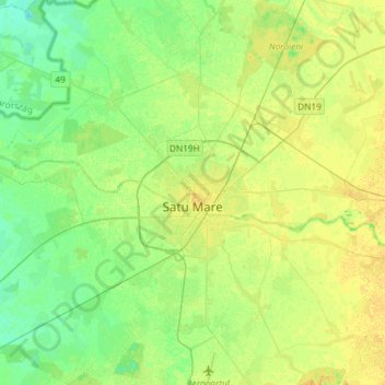
Name: Satu Mare topographic map, elevation, terrain.
Location: Satu Mare, Romania (47.69783 22.75602 47.89458 22.97684)
Average elevation: 407 ft
Minimum elevation: 377 ft
Maximum elevation: 436 ft
Make a donation
Gear up for your next adventure:
As an Amazon Associate, this site earns from qualifying purchases at no extra cost to you.
Other topographic maps
Click on a map to view its topography, its elevation and its terrain.
Make a donation
Gear up for your next adventure:
As an Amazon Associate, this site earns from qualifying purchases at no extra cost to you.