
Make a donation
Gear up for your next adventure:
As an Amazon Associate, this site earns from qualifying purchases at no extra cost to you.
Hooker Hills topographic map
Click on the map to display elevation.
Make a donation
Gear up for your next adventure:
As an Amazon Associate, this site earns from qualifying purchases at no extra cost to you.
About this map
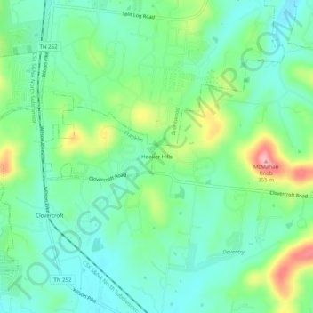
Name: Hooker Hills topographic map, elevation, terrain.
Average elevation: 820 ft
Minimum elevation: 686 ft
Maximum elevation: 1,135 ft
Williamson County trails, hiking, mountain biking, running and outdoor activities
Make a donation
Gear up for your next adventure:
As an Amazon Associate, this site earns from qualifying purchases at no extra cost to you.
Other topographic maps
Click on a map to view its topography, its elevation and its terrain.
Fairview
United States > Tennessee > Williamson County
Fairview was incorporated on July 28, 1959, under the Uniform City Manager-Commission Charter as set out in the Tennessee Code Annotated. Fairview city limits are located about one mile (1.6 km) southwest from the Nashville-Davidson County line and has two interstates passing through it (I-40 & I-840). With an…
Average elevation: 764 ft
Make a donation
Gear up for your next adventure:
As an Amazon Associate, this site earns from qualifying purchases at no extra cost to you.
Carrington Hills Pond
United States > Tennessee > Williamson County > Franklin
Average elevation: 735 ft
Make a donation
Gear up for your next adventure:
As an Amazon Associate, this site earns from qualifying purchases at no extra cost to you.
Fairview
United States > Tennessee > Williamson County
Fairview was incorporated on July 28, 1959, under the Uniform City Manager-Commission Charter as set out in the Tennessee Code Annotated. Fairview city limits are located about one mile (1.6 km) southwest from the Nashville-Davidson County line and has two interstates passing through it (I-40 & I-840). With an…
Average elevation: 764 ft