
Franklin topographic map
Click on the map to display elevation.
About this map
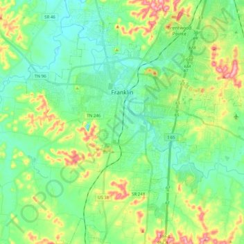
Name: Franklin topographic map, elevation, terrain.
Average elevation: 741 ft
Minimum elevation: 584 ft
Maximum elevation: 1,125 ft
Williamson County trails, hiking, mountain biking, running and outdoor activities
Other topographic maps
Click on a map to view its topography, its elevation and its terrain.
Stonehenge Estates
United States > Tennessee > Williamson County > Brentwood
Average elevation: 840 ft
Belle Rive Highlands
United States > Tennessee > Williamson County > Brentwood
Average elevation: 735 ft
Murray Lane Estates
United States > Tennessee > Williamson County > Brentwood
Average elevation: 787 ft
Williamson Estates
United States > Tennessee > Williamson County > Brentwood
Average elevation: 745 ft
Country Club Estates
United States > Tennessee > Williamson County > Brentwood
Average elevation: 712 ft
Carrington Hills Pond
United States > Tennessee > Williamson County > Franklin
Average elevation: 735 ft