Geolocate

Dendron topographic map

Click on the map to display elevation.

About this map

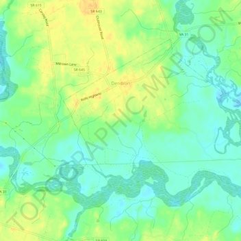
Name: Dendron topographic map, elevation, terrain.

Location: Dendron, Surry County, Virginia, United States (37.02298 -76.95041 37.05402 -76.89181)

Average elevation: 75 ft

Minimum elevation: 33 ft

Maximum elevation: 125 ft

Other topographic maps

Click on a map to view its topography, its elevation and its terrain.

Spring Grove

United States > Virginia > Surry County

Average elevation: 98 ft

Bayse Point

United States > Virginia > Surry County

Average elevation: 20 ft

Gear up for your next adventure:

🪵Folding Camp Saw - Compact saw for wood and campsite work
🧣Merino Neck Gaiters - Multi-functional headwear for wind and sun protection
👖Convertible Hiking Pants - Versatile zip-off pants for changing altitudes and temperatures
🔦LED Headlamp - Bright and durable LED headlamp for night navigation
🧭Outdoor Navigation Book - Learn advanced navigation skills

As an Amazon Associate, this site earns from qualifying purchases at no extra cost to you.