Geolocate

Spring Grove topographic map

Click on the map to display elevation.

About this map

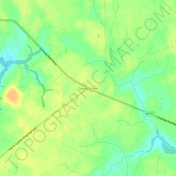
Name: Spring Grove topographic map, elevation, terrain.

Location: Spring Grove, Surry County, Virginia, 23881, United States (37.14570 -76.99330 37.18570 -76.95330)

Average elevation: 98 ft

Minimum elevation: 46 ft

Maximum elevation: 141 ft

Surry County trails, hiking, mountain biking, running and outdoor activities

Other topographic maps

Click on a map to view its topography, its elevation and its terrain.

Surry

United States > Virginia > Surry County

Average elevation: 105 ft

Dendron

United States > Virginia > Surry County

Average elevation: 75 ft

Surry

United States > Virginia > Surry County > Surry

Average elevation: 105 ft

Gear up for your next adventure:

🏔️Mountain Trail Maps - High‑detail maps for popular peaks
Backpacking Tents - Weight-optimized shelters for multi-day topographic surveys
🪶Camping Sleeping Pad - Comfortable sleeping pad for backpacking
🪶LED Camping Lantern - Bright lantern for camp lighting
👖Convertible Hiking Pants - Versatile zip-off pants for changing altitudes and temperatures

As an Amazon Associate, this site earns from qualifying purchases at no extra cost to you.