
Make a donation
Gear up for your next adventure:
As an Amazon Associate, this site earns from qualifying purchases at no extra cost to you.
Sioux Center topographic map
Click on the map to display elevation.
Make a donation
Gear up for your next adventure:
As an Amazon Associate, this site earns from qualifying purchases at no extra cost to you.
Sioux Center
Sioux Center is at an elevation of 1,445 feet (440 m) above sea level. It lies near the north-to-south ridge, or spine, of western Iowa. The eastern side of Sioux Center drains to the Floyd River. The western side drains to the Big Sioux River. This "divide" is profoundly unnoticeable. The area within a ten-mile (16 km) radius of Sioux Center has been divided into sections of one square mile each. The gravel and paved roads marking the sections do not swerve or contour for the slight hills or valleys.
Make a donation
Gear up for your next adventure:
As an Amazon Associate, this site earns from qualifying purchases at no extra cost to you.
About this map
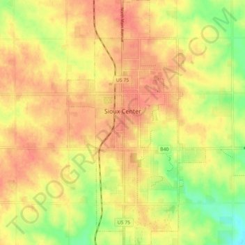
Name: Sioux Center topographic map, elevation, terrain.
Location: Sioux Center, Sioux County, Iowa, 51250, United States (43.04430 -96.19566 43.10895 -96.14569)
Average elevation: 1,421 ft
Minimum elevation: 1,306 ft
Maximum elevation: 1,486 ft
Sioux County trails, hiking, mountain biking, running and outdoor activities
Make a donation
Gear up for your next adventure:
As an Amazon Associate, this site earns from qualifying purchases at no extra cost to you.
Other topographic maps
Click on a map to view its topography, its elevation and its terrain.