
Chevy Chase topographic map
Click on the map to display elevation.
About this map
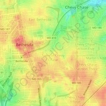
Name: Chevy Chase topographic map, elevation, terrain.
Average elevation: 325 ft
Minimum elevation: 203 ft
Maximum elevation: 400 ft
Montgomery County trails, hiking, mountain biking, running and outdoor activities
Other topographic maps
Click on a map to view its topography, its elevation and its terrain.
Carroll Knolls Park
United States > Maryland > Montgomery County > Silver Spring > Plyers Mill Estates
Average elevation: 364 ft
Damascus
United States > Maryland > Montgomery County
As an unincorporated area, Damascus' boundaries are not officially defined. Damascus is recognized by the United States Census Bureau as a census-designated place, and by the United States Geological Survey as a populated place located at 39°16′16″N 77°12′22″W / 39.27111°N 77.20611°W /…
Average elevation: 669 ft
Damascus
United States > Maryland > Montgomery County
As an unincorporated area, Damascus' boundaries are not officially defined. Damascus is recognized by the United States Census Bureau as a census-designated place, and by the United States Geological Survey as a populated place located. Damascus proper is a locally high spot at 847 ft (258m) above sea level,…
Average elevation: 669 ft
Upper Long Branch Neighborhood Park
United States > Maryland > Montgomery County > Four Corners
Average elevation: 285 ft
Clearspring Manor
United States > Maryland > Montgomery County > Damascus > Clearspring Manor
Average elevation: 705 ft
Hungerford Towne
United States > Maryland > Montgomery County > Rockville > Hungerford Towne
Average elevation: 400 ft