
Darnestown topographic map
Click on the map to display elevation.
About this map
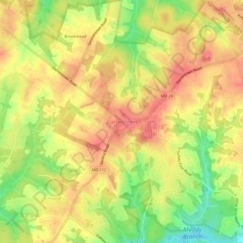
Name: Darnestown topographic map, elevation, terrain.
Location: Darnestown, Montgomery County, Maryland, United States (39.08322 -77.31181 39.12322 -77.27181)
Average elevation: 364 ft
Minimum elevation: 230 ft
Maximum elevation: 446 ft
Montgomery County trails, hiking, mountain biking, running and outdoor activities
Other topographic maps
Click on a map to view its topography, its elevation and its terrain.
Cabin John
United States > Maryland > Montgomery County > Cabin John
Historically, Cabin John has been part of the region known as the Potomac Gorge (Potomac Palisades), an approximately 15-mile-long (24 km) corridor or "fall zone" that sees a transition between the hard bedrock of the Piedmont to the softer rocks and soils of the Atlantic Coastal Plain and representing a drop…
Average elevation: 157 ft
Ten Mile Creek
United States > Maryland > Montgomery County > Ten Mile Creek
Average elevation: 545 ft
Damascus
United States > Maryland > Montgomery County > Damascus
As an unincorporated area, Damascus' boundaries are not officially defined. Damascus is recognized by the United States Census Bureau as a census-designated place, and by the United States Geological Survey as a populated place located at 39°16′16″N 77°12′22″W / 39.27111°N 77.20611°W /…
Average elevation: 640 ft
North Potomac
United States > Maryland > Montgomery County > North Potomac
Between the 1990 and 2000 census, North Potomac gained and lost land. The loss was caused when a portion of the North Potomac territory, plus Potomac territory, was used to create the Travilah census designated place. According to the United States Census Bureau, North Potomac has a total area of 6.6 square…
Average elevation: 381 ft
Carroll Knolls Park
United States > Maryland > Montgomery County > Silver Spring > Plyers Mill Estates
Average elevation: 364 ft
Burnt Mills West Special Park
United States > Maryland > Montgomery County > Burnt Mills > Burnt Mills Manor
Average elevation: 328 ft
Damascus
United States > Maryland > Montgomery County > Damascus
As an unincorporated area, Damascus' boundaries are not officially defined. Damascus is recognized by the United States Census Bureau as a census-designated place, and by the United States Geological Survey as a populated place located. Damascus proper is a locally high spot at 847 ft (258m) above sea level,…
Average elevation: 640 ft
Forest Glen
United States > Maryland > Montgomery County > Forest Glen > McKenney Hills
Average elevation: 344 ft
Colt Terrace Neighborhood Park
United States > Maryland > Montgomery County > Silver Spring
Average elevation: 390 ft
Forest Glen
United States > Maryland > Montgomery County > Forest Glen > McKenney Hills
Average elevation: 344 ft
Upper Long Branch Neighborhood Park
United States > Maryland > Montgomery County > Four Corners
Average elevation: 285 ft
Travilah
United States > Maryland > Montgomery County > Travilah
The United States Geological Survey lists six features in Montgomery County with Travilah in all or part of their name. The Travilah Census Designated Place has an ID of 2390400 and an elevation of 233 feet. It has a latitude of 390325N and a longitude of 0771445W—a location of 39°3′25″N…
Average elevation: 315 ft
North Bethesda
United States > Maryland > Montgomery County > North Bethesda
Average elevation: 322 ft
Forest Glen
United States > Maryland > Montgomery County > Forest Glen > Forest Estates
Average elevation: 344 ft