
Buhl topographic map
Click on the map to display elevation.
About this map
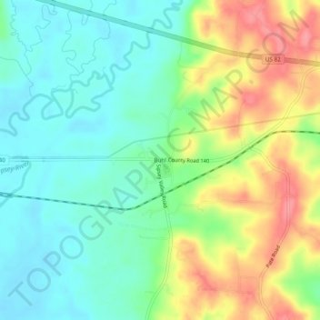
Name: Buhl topographic map, elevation, terrain.
Location: Buhl, Tuscaloosa County, Alabama, United States (33.23706 -87.77279 33.27706 -87.73279)
Average elevation: 295 ft
Minimum elevation: 190 ft
Maximum elevation: 466 ft
Tuscaloosa County trails, hiking, mountain biking, running and outdoor activities
Other topographic maps
Click on a map to view its topography, its elevation and its terrain.
Tuscaloosa
United States > Alabama > Tuscaloosa County
The Tuscaloosa National Airport (KTCL) is 3.5 miles northwest of Tuscaloosa in Tuscaloosa County, Alabama. Owned and operated by the City of Tuscaloosa, the airport is an FAA-designated National General Aviation Airport and Part 139 Certified. Tuscaloosa National Airport covers 826 acres at an elevation of…
Average elevation: 318 ft