Geolocate

Terschelling topographic map

Click on the map to display elevation.

About this map

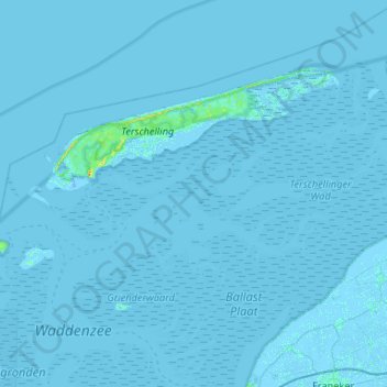
Name: Terschelling topographic map, elevation, terrain.

Location: Terschelling, Frisia, Netherlands (53.21561 5.08707 53.47158 5.61283)

Average elevation: 0 ft

Minimum elevation: -39 ft

Maximum elevation: 79 ft

Other topographic maps

Click on a map to view its topography, its elevation and its terrain.

Oost-Vlieland

Netherlands > Frisia

Average elevation: 7 ft

Kooiplaats

Netherlands > Frisia > Buren

Average elevation: 3 ft

Loënga

Netherlands > Frisia > Loënga

Average elevation: 0 ft

Vierhuizen

Netherlands > Frisia > Allingawier

Average elevation: -7 ft

Leeuwarden

Netherlands > Frisia > Leeuwarden

Average elevation: 0 ft

Gear up for your next adventure:

👖Convertible Hiking Pants - Versatile zip-off pants for changing altitudes and temperatures
🚪Portable Camp Chair - Foldable chair for comfort at camp
🥇GPS Hiking Watch - Multi‑sport GPS watch with navigation and trail tracking
🪄Magnetic Compass - Accurate compass for navigation
🪶Camp Gear Gift Set - Perfect gift bundle for outdoor fans

As an Amazon Associate, this site earns from qualifying purchases at no extra cost to you.