
Make a donation
Gear up for your next adventure:
As an Amazon Associate, this site earns from qualifying purchases at no extra cost to you.
Pompano Beach topographic map
Click on the map to display elevation.
Make a donation
Gear up for your next adventure:
As an Amazon Associate, this site earns from qualifying purchases at no extra cost to you.
Pompano Beach
Pompano Beach features a low-elevation coastal landscape typical of southeastern Florida. With an average elevation around 20 feet above sea level, the area is flat, gradually sloping toward the Atlantic Ocean to the east. The terrain includes a blend of sandy beach areas along the coast and slightly higher, well-drained inland regions that were once part of Florida’s original wetlands. Its flat topography and proximity to the ocean make it susceptible to flooding, particularly in low-lying areas, a challenge that has shaped both its residential zoning and environmental planning efforts, especially concerning stormwater management and conservation of natural water flow.
Make a donation
Gear up for your next adventure:
As an Amazon Associate, this site earns from qualifying purchases at no extra cost to you.
About this map
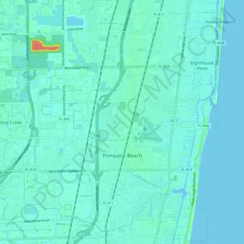
Name: Pompano Beach topographic map, elevation, terrain.
Location: Pompano Beach, Broward County, Florida, United States (26.20598 -80.19561 26.29766 -80.08134)
Average elevation: 20 ft
Minimum elevation: 0 ft
Maximum elevation: 148 ft
Broward County trails, hiking, mountain biking, running and outdoor activities
Make a donation
Gear up for your next adventure:
As an Amazon Associate, this site earns from qualifying purchases at no extra cost to you.
Other topographic maps
Click on a map to view its topography, its elevation and its terrain.
Lauderdale Harbors
United States > Florida > Broward County > Fort Lauderdale
Average elevation: 20 ft
Make a donation
Gear up for your next adventure:
As an Amazon Associate, this site earns from qualifying purchases at no extra cost to you.
Bonita Bay
United States > Florida > Broward County > Fort Lauderdale > Soroka Shores
Average elevation: 13 ft
Make a donation
Gear up for your next adventure:
As an Amazon Associate, this site earns from qualifying purchases at no extra cost to you.
Middle River Vista
United States > Florida > Broward County > Fort Lauderdale
Average elevation: 23 ft
Make a donation
Gear up for your next adventure:
As an Amazon Associate, this site earns from qualifying purchases at no extra cost to you.
Make a donation
Gear up for your next adventure:
As an Amazon Associate, this site earns from qualifying purchases at no extra cost to you.
Make a donation
Gear up for your next adventure:
As an Amazon Associate, this site earns from qualifying purchases at no extra cost to you.
Make a donation
Gear up for your next adventure:
As an Amazon Associate, this site earns from qualifying purchases at no extra cost to you.
Cypress Isles Estates
United States > Florida > Broward County > Pompano Beach
Average elevation: 20 ft
Make a donation
Gear up for your next adventure:
As an Amazon Associate, this site earns from qualifying purchases at no extra cost to you.
Make a donation
Gear up for your next adventure:
As an Amazon Associate, this site earns from qualifying purchases at no extra cost to you.
Bonita Bay
United States > Florida > Broward County > Fort Lauderdale > Soroka Shores
Average elevation: 13 ft
Fort Lauderdale Beach
United States > Florida > Broward County > Fort Lauderdale > Birch Ocean Front
Average elevation: 10 ft
Make a donation
Gear up for your next adventure:
As an Amazon Associate, this site earns from qualifying purchases at no extra cost to you.