Geolocate

Caravela topographic map

Interactive map

Click on the map to display elevation.

About this map

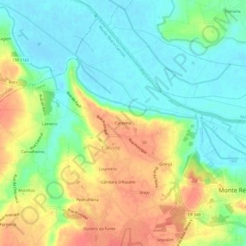
Name: Caravela topographic map, elevation, terrain.

Location: Caravela, Monte Real e Carvide, Leiria, 2425-345, Portugal (39.84181 -8.90831 39.88181 -8.86831)

Average elevation: 82 ft

Minimum elevation: 7 ft

Maximum elevation: 180 ft

Other topographic maps

Click on a map to view its topography, its elevation and its terrain.

Monte Real

Portugal > Leiria > Leiria

Monte Real, Leiria, 2425-060, Portugal

Average elevation: 131 ft

Leiria

Portugal > Leiria > Leiria

Leiria, Leiria, Pousos, Barreira e Cortes, Leiria, 2400-217 LEIRIA, Portugal

Average elevation: 476 ft

Leiria

Portugal > Leiria > Leiria

Leiria, Arrabal, Leiria, 2420-020 ARRABAL, Portugal

Average elevation: 732 ft

Maceira

Portugal > Leiria > Leiria

Maceira, Leiria, Portugal

Average elevation: 397 ft