
Fort Scott topographic map
Click on the map to display elevation.
About this map
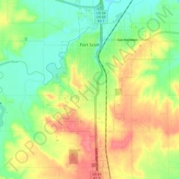
Name: Fort Scott topographic map, elevation, terrain.
Location: Fort Scott, Bourbon County, Kansas, 66701, United States (37.78583 -94.73034 37.85780 -94.67602)
Average elevation: 873 ft
Minimum elevation: 771 ft
Maximum elevation: 994 ft
Bourbon County trails, hiking, mountain biking, running and outdoor activities
Other topographic maps
Click on a map to view its topography, its elevation and its terrain.
Fort Scott
United States > Kansas > Bourbon County > Fort Scott
Fort Scott is located at 37°50′7″N 94°42′7″W / 37.83528°N 94.70194°W / 37.83528; -94.70194 (37.835180, −94.702015) at an elevation of 846 feet (258 m). It lies on the Osage Plains on the south side of the Marmaton River. Located at the intersection of U.S. Routes 54 and 69 in southeast…
Average elevation: 853 ft