
Make a donation
Gear up for your next adventure:
As an Amazon Associate, this site earns from qualifying purchases at no extra cost to you.
Prince Charles Island topographic map
Click on the map to display elevation.
Make a donation
Gear up for your next adventure:
As an Amazon Associate, this site earns from qualifying purchases at no extra cost to you.
About this map
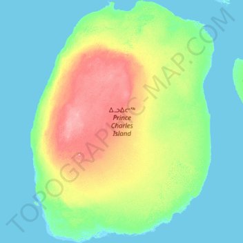
Name: Prince Charles Island topographic map, elevation, terrain.
Location: Prince Charles Island, Nunavut, Canada (67.20600 -77.28506 68.34595 -75.00334)
Average elevation: 56 ft
Minimum elevation: -10 ft
Maximum elevation: 328 ft
Make a donation
Gear up for your next adventure:
As an Amazon Associate, this site earns from qualifying purchases at no extra cost to you.
Other topographic maps
Click on a map to view its topography, its elevation and its terrain.
Arctic Bay
Canada > Nunavut > Qikiqtaaluk Region
Arctic Bay experiences a tundra climate (Köppen: ET) like most northern Canadian territories at low elevations, with long, very cold winters and short, cool to cold summers. July is the only month with an average low temperature above freezing. Its climate does not differ from the more severe subarctic…
Average elevation: 525 ft
Make a donation
Gear up for your next adventure:
As an Amazon Associate, this site earns from qualifying purchases at no extra cost to you.
Make a donation
Gear up for your next adventure:
As an Amazon Associate, this site earns from qualifying purchases at no extra cost to you.