Geolocate

Somerville topographic map

Click on the map to display elevation.

About this map

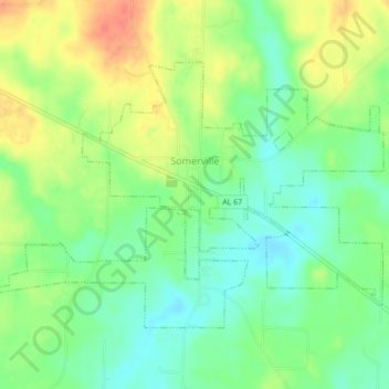
Name: Somerville topographic map, elevation, terrain.

Location: Somerville, Morgan County, Alabama, United States (34.44235 -86.83512 34.49685 -86.75208)

Average elevation: 669 ft

Minimum elevation: 564 ft

Maximum elevation: 804 ft

Morgan County trails, hiking, mountain biking, running and outdoor activities

Other topographic maps

Click on a map to view its topography, its elevation and its terrain.

Laceys Spring

United States > Alabama > Morgan County

Average elevation: 699 ft

Basham

United States > Alabama > Morgan County > Decatur

Average elevation: 640 ft

Florette

United States > Alabama > Morgan County

Average elevation: 666 ft

Decatur

United States > Alabama > Morgan County

Average elevation: 610 ft

Wolftown

United States > Alabama > Morgan County > Wolftown

Average elevation: 666 ft

Decatur

United States > Alabama > Morgan County > Decatur > Decatur

Average elevation: 623 ft

Falkville

United States > Alabama > Morgan County

Average elevation: 614 ft

Gear up for your next adventure:

🔦Compact Flashlight - Reliable flashlight for emergencies
🎒Trekking Poles - Sturdy poles for balance and stability on rough terrain
🔦Powerful Headlamps - Ultra-bright hands-free lighting for night navigation
🧺Microfiber Travel Towels - Compact and fast-drying towels for trail use
📱Heavy-Duty Phone Cases - Drop-proof and waterproof protection for outdoor navigation

As an Amazon Associate, this site earns from qualifying purchases at no extra cost to you.