
Make a donation
Gear up for your next adventure:
As an Amazon Associate, this site earns from qualifying purchases at no extra cost to you.
Penn State Forest topographic map
Click on the map to display elevation.
Make a donation
Gear up for your next adventure:
As an Amazon Associate, this site earns from qualifying purchases at no extra cost to you.
Penn State Forest
In 1912, the state ran a 9 mi (14 km) telephone line across what was initially called Penn Reserve. A wooden fire lookout tower was constructed on Bear Swamp Hill (elevation 165 ft (50 m)) in 1915. After the wooden tower burnt down, a modern fire lookout tower was built in 1960. That tower was destroyed when a plane crashed through it in 1971. An Air National Guard pilot named William F. Dimas, flying from McGuire Air Force Base, crashed during practice bombing runs in a supersonic F-105 Thunderchief over the Warren Grove Gunnery Range, which is adjacent to the state forest. The crash killed the pilot and destroyed about 1000 trees along a path about 40 ft (12 m) wide and 1 mi (1.6 km) long.
Make a donation
Gear up for your next adventure:
As an Amazon Associate, this site earns from qualifying purchases at no extra cost to you.
About this map
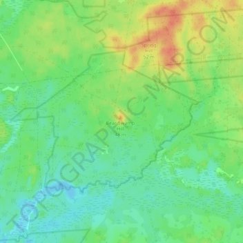
Name: Penn State Forest topographic map, elevation, terrain.
Average elevation: 89 ft
Minimum elevation: 36 ft
Maximum elevation: 171 ft
Burlington County trails, hiking, mountain biking, running and outdoor activities
Make a donation
Gear up for your next adventure:
As an Amazon Associate, this site earns from qualifying purchases at no extra cost to you.
Other topographic maps
Click on a map to view its topography, its elevation and its terrain.
Franklin Park
United States > New Jersey > Burlington County > Willingboro Township
Average elevation: 36 ft
Make a donation
Gear up for your next adventure:
As an Amazon Associate, this site earns from qualifying purchases at no extra cost to you.
Indian Mills
United States > New Jersey > Burlington County > Shamong Township
Average elevation: 82 ft
Make a donation
Gear up for your next adventure:
As an Amazon Associate, this site earns from qualifying purchases at no extra cost to you.
Make a donation
Gear up for your next adventure:
As an Amazon Associate, this site earns from qualifying purchases at no extra cost to you.
Colemantown
United States > New Jersey > Burlington County > Mount Laurel Township
Average elevation: 66 ft
Make a donation
Gear up for your next adventure:
As an Amazon Associate, this site earns from qualifying purchases at no extra cost to you.
Freedom Park
United States > New Jersey > Burlington County > Medford Township
Average elevation: 52 ft
Coxs Corner
United States > New Jersey > Burlington County > Mount Laurel Township
Average elevation: 69 ft
Make a donation
Gear up for your next adventure:
As an Amazon Associate, this site earns from qualifying purchases at no extra cost to you.
Burlington
United States > New Jersey > Burlington County > Burlington City > Burlington
Average elevation: 36 ft
Make a donation
Gear up for your next adventure:
As an Amazon Associate, this site earns from qualifying purchases at no extra cost to you.
Make a donation
Gear up for your next adventure:
As an Amazon Associate, this site earns from qualifying purchases at no extra cost to you.
Chambers Corners
United States > New Jersey > Burlington County > Chambers Corners
Average elevation: 62 ft
Garfield Park East
United States > New Jersey > Burlington County > Willingboro > Garfield Park East
Average elevation: 52 ft
Apple Pie Hill Station Fire Tower
United States > New Jersey > Burlington County > Tabernacle Township
Average elevation: 112 ft
Make a donation
Gear up for your next adventure:
As an Amazon Associate, this site earns from qualifying purchases at no extra cost to you.
Fellowship
United States > New Jersey > Burlington County > Mount Laurel Township
Average elevation: 52 ft