Geolocate

Aniwa topographic map

Click on the map to display elevation.

About this map

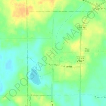
Name: Aniwa topographic map, elevation, terrain.

Location: Aniwa, Shawano County, Wisconsin, United States (45.00072 -89.22376 45.02222 -89.19408)

Average elevation: 1,407 ft

Minimum elevation: 1,362 ft

Maximum elevation: 1,463 ft

Shawano County trails, hiking, mountain biking, running and outdoor activities

Other topographic maps

Click on a map to view its topography, its elevation and its terrain.

Pittsfield

United States > Wisconsin > Shawano County

Average elevation: 804 ft

Pella

United States > Wisconsin > Shawano County

Average elevation: 922 ft

Caroline

United States > Wisconsin > Shawano County

Average elevation: 988 ft

Gear up for your next adventure:

🔋Rechargeable Batteries - Power up your outdoor devices
🧭Map Reading Tools - Tools and kits for map navigation
🧣Hiking Neck Gaiter - Multi‑use neck protection for outdoor weather
Camping Coffee Makers - Enjoy premium coffee at the summit or campsite
🪑Portable Camp Table - Compact table for campsite meals

As an Amazon Associate, this site earns from qualifying purchases at no extra cost to you.