
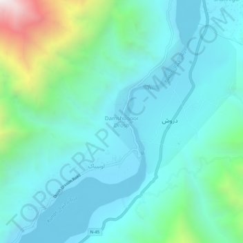
Damshogoor Drosh topographic map
Interactive map
Click on the map to display elevation.
About this map
Name: Damshogoor Drosh topographic map, elevation, terrain.
Average elevation: 5,079 ft
Minimum elevation: 4,140 ft
Maximum elevation: 9,131 ft
Other topographic maps
Click on a map to view its topography, its elevation and its terrain.
Madak Lusht
Pakistan > Khyber Pakhtunkhwa > Former Chitrāl District
Madak Lusht, Lower Chitral District, Former Chitrāl District, Malakand Division, Khyber Pakhtunkhwa, Pakistan
Average elevation: 9,862 ft
Lower Chitral District
Pakistan > Khyber Pakhtunkhwa > Former Chitrāl District
Lower Chitral District, Former Chitrāl District, Malakand Division, Khyber Pakhtunkhwa, 17220, Pakistan
Average elevation: 12,090 ft
Bang Bala
Pakistan > Khyber Pakhtunkhwa > Former Chitrāl District
Bang Bala, Upper Chitral District, Former Chitrāl District, Malakand Division, Khyber Pakhtunkhwa, Pakistan
Average elevation: 9,590 ft
Drosh
Pakistan > Khyber Pakhtunkhwa > Former Chitrāl District > Drosh
Drosh, Lower Chitral District, Former Chitrāl District, Malakand Division, Khyber Pakhtunkhwa, Pakistan
Average elevation: 6,073 ft
Former Chitrāl District
Pakistan > Khyber Pakhtunkhwa > Former Chitrāl District
Former Chitrāl District, Khyber Pakhtunkhwa, Pakistan
Average elevation: 12,234 ft
Tirich Mir
Pakistan > Khyber Pakhtunkhwa > Former Chitrāl District
Tirich Mir, Former Chitrāl District, Khyber Pakhtunkhwa, Pakistan
Average elevation: 22,316 ft