
Make a donation
Gear up for your next adventure:
As an Amazon Associate, this site earns from qualifying purchases at no extra cost to you.
Taymyr Peninsula topographic map
Click on the map to display elevation.
Make a donation
Gear up for your next adventure:
As an Amazon Associate, this site earns from qualifying purchases at no extra cost to you.
About this map
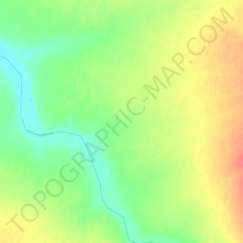
Name: Taymyr Peninsula topographic map, elevation, terrain.
Average elevation: 778 ft
Minimum elevation: 702 ft
Maximum elevation: 869 ft
Make a donation
Gear up for your next adventure:
As an Amazon Associate, this site earns from qualifying purchases at no extra cost to you.
Other topographic maps
Click on a map to view its topography, its elevation and its terrain.
Arctic Ice Cap
Russia > Krasnoyarsk Krai > Taymyrsky Dolgano-Nenetsky District
Average elevation: 56 ft
Matusevich Ice Shelf
Russia > Krasnoyarsk Krai > Taymyrsky Dolgano-Nenetsky District
Average elevation: 692 ft
Make a donation
Gear up for your next adventure:
As an Amazon Associate, this site earns from qualifying purchases at no extra cost to you.
сельское поселение Хатанга
Russia > Krasnoyarsk Krai > Taymyrsky Dolgano-Nenetsky District
Average elevation: 515 ft
городское поселение Дудинка
Russia > Krasnoyarsk Krai > Taymyrsky Dolgano-Nenetsky District
Average elevation: 889 ft
Make a donation
Gear up for your next adventure:
As an Amazon Associate, this site earns from qualifying purchases at no extra cost to you.