
Encamp topographic map
Click on the map to display elevation.
Encamp
Radio Andorra operated a transmitter at Lake Engolasters in Encamp from 7 August 1939 until 9 April 1981. The antenna still exists at an elevation of 1,600 metres (5,200 ft) (coordinates: 42°31′18″N 1°34′10″E / 42.52167°N 1.56944°E / 42.52167; 1.56944 (Radio Andorra transmitter)).
About this map
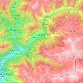
Name: Encamp topographic map, elevation, terrain.
Location: Encamp, AD200, Andorra (42.48980 1.54605 42.55920 1.73889)
Average elevation: 6,535 ft
Minimum elevation: 2,933 ft
Maximum elevation: 9,534 ft
Other topographic maps
Click on a map to view its topography, its elevation and its terrain.