
Thank you for supporting this site ❤️
Make a donation
Make a donation
Gear up for your next adventure:
As an Amazon Associate, this site earns from qualifying purchases at no extra cost to you.
Niedernberg topographic map
Click on the map to display elevation.
Thank you for supporting this site ❤️
Make a donation
Make a donation
Gear up for your next adventure:
As an Amazon Associate, this site earns from qualifying purchases at no extra cost to you.
About this map
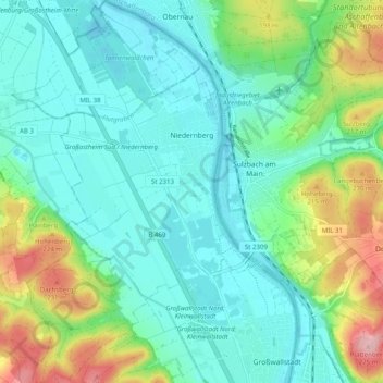
Name: Niedernberg topographic map, elevation, terrain.
Location: Niedernberg, Landkreis Miltenberg, Bavaria, 63843, Germany (49.87426 9.09361 49.93848 9.15327)
Average elevation: 502 ft
Minimum elevation: 361 ft
Maximum elevation: 906 ft
Thank you for supporting this site ❤️
Make a donation
Make a donation
Gear up for your next adventure:
As an Amazon Associate, this site earns from qualifying purchases at no extra cost to you.
Other topographic maps
Click on a map to view its topography, its elevation and its terrain.
Miltenberg
Germany > Bavaria > Landkreis Miltenberg > Miltenberg > Miltenberg
Average elevation: 915 ft