
Make a donation
Gear up for your next adventure:
As an Amazon Associate, this site earns from qualifying purchases at no extra cost to you.
Lehavim topographic map
Click on the map to display elevation.
Make a donation
Gear up for your next adventure:
As an Amazon Associate, this site earns from qualifying purchases at no extra cost to you.
About this map
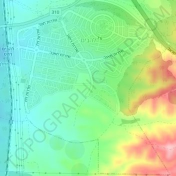
Name: Lehavim topographic map, elevation, terrain.
Location: Lehavim, Beersheba Subdistrict, South District, Israel (31.34815 34.78953 31.39349 34.82946)
Average elevation: 1,037 ft
Minimum elevation: 810 ft
Maximum elevation: 1,503 ft
Make a donation
Gear up for your next adventure:
As an Amazon Associate, this site earns from qualifying purchases at no extra cost to you.
Other topographic maps
Click on a map to view its topography, its elevation and its terrain.
Dimona
Dimona is located in the Negev Desert. The city stands at an elevation of around 550–600 metres (1,800–1,970 ft) above sea level.
Average elevation: 1,834 ft
Make a donation
Gear up for your next adventure:
As an Amazon Associate, this site earns from qualifying purchases at no extra cost to you.
Make a donation
Gear up for your next adventure:
As an Amazon Associate, this site earns from qualifying purchases at no extra cost to you.
Sde Boker
Israel > South District > Ramat Negev Regional Council > Sde Boker
Average elevation: 1,594 ft