
Make a donation
Gear up for your next adventure:
As an Amazon Associate, this site earns from qualifying purchases at no extra cost to you.
Darchen topographic map
Click on the map to display elevation.
Make a donation
Gear up for your next adventure:
As an Amazon Associate, this site earns from qualifying purchases at no extra cost to you.
About this map
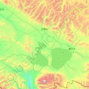
Name: Darchen topographic map, elevation, terrain.
Location: Darchen, Purang County, Ngari Prefecture, Tibet, China (30.42061 80.54186 31.21109 81.60714)
Average elevation: 16,430 ft
Minimum elevation: 13,235 ft
Maximum elevation: 25,016 ft
Make a donation
Gear up for your next adventure:
As an Amazon Associate, this site earns from qualifying purchases at no extra cost to you.
Other topographic maps
Click on a map to view its topography, its elevation and its terrain.
Mount Kailash
China > Tibet > Purang County > Darchen
Mount Kailash (also Kailasa; Kangrinboqê or Gang Rinpoche; Tibetan: གངས་རིན་པོ་ཆེ; simplified Chinese: 冈仁波齐峰; traditional Chinese: 岡仁波齊峰; Sanskrit: कैलास, IAST: Kailāsa), is a mountain in the Ngari Prefecture, Tibet Autonomous Region of China. It has an…
Average elevation: 18,885 ft
Gurla Mandhata
China > Tibet > Purang County > Purang
In 1905, T. G. Longstaff made an attempt on the west face of Gurla Mandhata with two alpine guides and six porters. After suffering a 900 feet (270 m) fall during an avalanche, they turned back around 7,000 m (23,000 ft) upon finding fresh snow was falling too heavily to reach the summit with their provisions.…
Average elevation: 22,680 ft
Mount Kailash
China > Tibet > Purang County > Darchen
Mount Kailash (also Kailasa, Gang Tise and Gang Rinpoche or Kangrinboqê) is a mountain in Ngari Prefecture, Tibet Autonomous Region of China. It lies in the Gangdise Shan mountain range of the Transhimalaya, in the western part of the Tibetan Plateau. The peak of Mount Kailash is located at an elevation of…
Average elevation: 18,885 ft
Make a donation
Gear up for your next adventure:
As an Amazon Associate, this site earns from qualifying purchases at no extra cost to you.
Mount Kailash
China > Tibet > Purang County > Darchen
Mount Kailash (also Kailasa, Gang Tise and Gang Rinpoche or Kangrinboqê) is a mountain in Ngari Prefecture, Tibet Autonomous Region of China. It lies in the Gangdise Shan mountain range of the Transhimalaya, in the western part of the Tibetan Plateau. The peak of Mount Kailash is located at an elevation of…
Average elevation: 18,885 ft
Mount Kailash
China > Tibet > Purang County > Darchen
Mount Kailash (also Kailasa; Kangrinboqê or Gang Rinpoche; Standard Tibetan: གངས་རིན་པོ་ཆེ; simplified Chinese: 冈仁波齐峰; traditional Chinese: 岡仁波齊峰; pinyin: Gāngrénbōqí Fēng; Sanskrit: कैलास, IAST: Kailāsa) is a mountain in Ngari Prefecture, Tibet…
Average elevation: 18,885 ft
Make a donation
Gear up for your next adventure:
As an Amazon Associate, this site earns from qualifying purchases at no extra cost to you.