
Make a donation
Gear up for your next adventure:
As an Amazon Associate, this site earns from qualifying purchases at no extra cost to you.
Jochberg topographic map
Click on the map to display elevation.
Make a donation
Gear up for your next adventure:
As an Amazon Associate, this site earns from qualifying purchases at no extra cost to you.
Jochberg
Die komplette Liste der Statistik Austria ist in: Topographische Siedlungskennzeichnung nach STAT
Make a donation
Gear up for your next adventure:
As an Amazon Associate, this site earns from qualifying purchases at no extra cost to you.
About this map
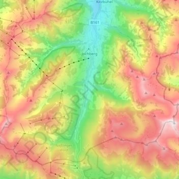
Name: Jochberg topographic map, elevation, terrain.
Location: Jochberg, Bezirk Kitzbühel, Tirol, 6373, Österreich (47.31131 12.33526 47.40479 12.49860)
Average elevation: 5,000 ft
Minimum elevation: 2,618 ft
Maximum elevation: 7,654 ft
Make a donation
Gear up for your next adventure:
As an Amazon Associate, this site earns from qualifying purchases at no extra cost to you.
Other topographic maps
Click on a map to view its topography, its elevation and its terrain.
Scheffau
Österreich > Tirol > Bezirk Kitzbühel > Marktgemeinde St. Johann in Tirol
Average elevation: 3,081 ft
Weichsölln
Österreich > Tirol > Bezirk Kitzbühel > Hopfgarten im Brixental
Average elevation: 2,772 ft
Schafsiedel
Österreich > Tirol > Bezirk Kitzbühel > Hopfgarten im Brixental
Average elevation: 6,844 ft
Make a donation
Gear up for your next adventure:
As an Amazon Associate, this site earns from qualifying purchases at no extra cost to you.
Außersalvenberg
Österreich > Tirol > Bezirk Kitzbühel > Westendorf > Feichten
Average elevation: 3,097 ft
Make a donation
Gear up for your next adventure:
As an Amazon Associate, this site earns from qualifying purchases at no extra cost to you.
Schwaigerberg
Österreich > Tirol > Bezirk Kitzbühel > Westendorf > Unterwindau
Average elevation: 3,031 ft
Make a donation
Gear up for your next adventure:
As an Amazon Associate, this site earns from qualifying purchases at no extra cost to you.
Hahnenkamm
Österreich > Tirol > Bezirk Kitzbühel > Kitzbühel
Über Kitzbühel erhebt sich der Hahnenkamm mit einer Höhe von 1712 m ü. A. Der eigentlich höchste Punkt am Hahnenkamm ist die Ehrenbachhöhe mit einer Höhe von 1802 m ü. A.
Average elevation: 4,738 ft
Pillersee
Österreich > Tirol > Bezirk Kitzbühel > Sankt Ulrich am Pillersee > Brunnerau
Seine Entstehung verdankt der Pillersee einem Bergsturz vor etwa 15.000 Jahren, der den Abfluss in Höhe der Öfenschlucht unterbrach und so den Pillersee aufstaute.
Average elevation: 3,530 ft
Make a donation
Gear up for your next adventure:
As an Amazon Associate, this site earns from qualifying purchases at no extra cost to you.
Reith bei Kitzbühel
Österreich > Tirol > Bezirk Kitzbühel > Gemeinde Reith bei Kitzbühel > Reith bei Kitzbühel
Average elevation: 2,999 ft
Schattenried
Österreich > Tirol > Bezirk Kitzbühel > Going am Wilden Kaiser
Average elevation: 2,723 ft
Going
Österreich > Tirol > Bezirk Kitzbühel > Gemeinde Going am Wilden Kaiser > Going
Average elevation: 2,927 ft
Markbachjoch
Österreich > Tirol > Bezirk Kitzbühel > Marktgemeinde Hopfgarten im Brixental
Average elevation: 3,865 ft
Make a donation
Gear up for your next adventure:
As an Amazon Associate, this site earns from qualifying purchases at no extra cost to you.
Hahnenkamm
Österreich > Tirol > Bezirk Kitzbühel > Stadt Kitzbühel
Über Kitzbühel erhebt sich der Hahnenkamm mit einer Höhe von 1712 m ü. A. Der eigentlich höchste Punkt am Hahnenkamm ist die Ehrenbachhöhe mit einer Höhe von 1802 m ü. A.
Average elevation: 4,724 ft
Weiberndorf
Österreich > Tirol > Bezirk Kitzbühel > Marktgemeinde St. Johann in Tirol > Weiberndorf
Average elevation: 2,585 ft
Make a donation
Gear up for your next adventure:
As an Amazon Associate, this site earns from qualifying purchases at no extra cost to you.
Kelchsau
Österreich > Tirol > Bezirk Kitzbühel > Hopfgarten im Brixental > Kelchsau
Average elevation: 3,720 ft
Steinplatte
Österreich > Tirol > Bezirk Kitzbühel > Waidring
Die Steinplatte liegt im Gemeindegebiet von Unken und Lofer im Saalachtal, Pinzgau und von Waidring im Bezirk Kitzbühel. Der Hauptgipfel (1869 m ü. A.) liegt am Westrand der Formation. Oberhalb des Strubtals erstreckt sich die etwa 1000 Höhenmeter hohe Sonnwand bis zum Grubhörndl (1747 m ü. A.) und die…
Average elevation: 4,698 ft
Pillersee
Österreich > Tirol > Bezirk Kitzbühel > Sankt Ulrich am Pillersee > Brunnerau
Seine Entstehung verdankt der Pillersee einem Bergsturz vor etwa 15.000 Jahren, der den Abfluss in Höhe der Öfenschlucht unterbrach und so den Pillersee aufstaute.
Average elevation: 3,530 ft
Make a donation
Gear up for your next adventure:
As an Amazon Associate, this site earns from qualifying purchases at no extra cost to you.
Make a donation
Gear up for your next adventure:
As an Amazon Associate, this site earns from qualifying purchases at no extra cost to you.
Buchensteinwand
Österreich > Tirol > Bezirk Kitzbühel > Sankt Ulrich am Pillersee
Average elevation: 3,638 ft
Make a donation
Gear up for your next adventure:
As an Amazon Associate, this site earns from qualifying purchases at no extra cost to you.
Make a donation
Gear up for your next adventure:
As an Amazon Associate, this site earns from qualifying purchases at no extra cost to you.
Make a donation
Gear up for your next adventure:
As an Amazon Associate, this site earns from qualifying purchases at no extra cost to you.
Brixental
Österreich > Tirol > Bezirk Kitzbühel > Westendorf
Mit rund 24.000 Gästebetten, 1,68 Millionen Nächtigungen im Winter und 1,32 Millionen im Sommer (Stand 2018) stellt der Tourismus einen wichtigen Wirtschaftszweig dar. Die SkiWelt Wilder Kaiser – Brixental ist eines der größten Schigebiete Österreichs. Neben den zahlreichen Beherbergungsbetrieben und…
Average elevation: 3,274 ft