
Santa Cruz de Pichiu topographic map
Interactive map
Click on the map to display elevation.
About this map
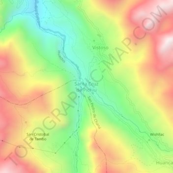
Name: Santa Cruz de Pichiu topographic map, elevation, terrain.
Average elevation: 12,592 ft
Minimum elevation: 10,974 ft
Maximum elevation: 14,370 ft
Other topographic maps
Click on a map to view its topography, its elevation and its terrain.
Wishllac
Perú > Áncash > San Pedro de Chaná > Huancayoc
Wishllac, Huancayoc, San Pedro de Chaná, Huari, Áncash, Perú
Average elevation: 13,094 ft
Chana
Perú > Áncash > San Pedro de Chaná
Chana, San Pedro de Chaná, Huari, Áncash, Perú
Average elevation: 11,302 ft