
Make a donation
Gear up for your next adventure:
As an Amazon Associate, this site earns from qualifying purchases at no extra cost to you.
Vorokhta topographic map
Click on the map to display elevation.
Make a donation
Gear up for your next adventure:
As an Amazon Associate, this site earns from qualifying purchases at no extra cost to you.
Vorokhta
Located at an elevation of 800 metres above sea level, it is known for its close ties to the Hutsuls – an ethno-cultural group of Ukrainians who live in the Carpathians, and is often regarded as a Hutsul capital.
Make a donation
Gear up for your next adventure:
As an Amazon Associate, this site earns from qualifying purchases at no extra cost to you.
About this map
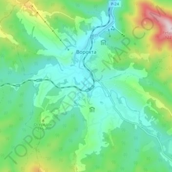
Name: Vorokhta topographic map, elevation, terrain.
Average elevation: 2,822 ft
Minimum elevation: 2,362 ft
Maximum elevation: 4,144 ft
Make a donation
Gear up for your next adventure:
As an Amazon Associate, this site earns from qualifying purchases at no extra cost to you.
Other topographic maps
Click on a map to view its topography, its elevation and its terrain.