
Make a donation
Gear up for your next adventure:
As an Amazon Associate, this site earns from qualifying purchases at no extra cost to you.
Rusiv topographic map
Click on the map to display elevation.
Make a donation
Gear up for your next adventure:
As an Amazon Associate, this site earns from qualifying purchases at no extra cost to you.
About this map
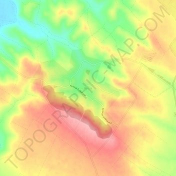
Name: Rusiv topographic map, elevation, terrain.
Average elevation: 974 ft
Minimum elevation: 738 ft
Maximum elevation: 1,155 ft
Make a donation
Gear up for your next adventure:
As an Amazon Associate, this site earns from qualifying purchases at no extra cost to you.
Other topographic maps
Click on a map to view its topography, its elevation and its terrain.
Make a donation
Gear up for your next adventure:
As an Amazon Associate, this site earns from qualifying purchases at no extra cost to you.
Make a donation
Gear up for your next adventure:
As an Amazon Associate, this site earns from qualifying purchases at no extra cost to you.
Vorokhta
Ukraine > Ivano-Frankivsk Oblast
Located at an elevation of 800 metres above sea level, it is known for its close ties to the Hutsuls – an ethno-cultural group of Ukrainians who live in the Carpathians, and is often regarded as a Hutsul capital.
Average elevation: 2,822 ft
Make a donation
Gear up for your next adventure:
As an Amazon Associate, this site earns from qualifying purchases at no extra cost to you.