
Make a donation
Gear up for your next adventure:
As an Amazon Associate, this site earns from qualifying purchases at no extra cost to you.
Tenaya Lake topographic map
Click on the map to display elevation.
Make a donation
Gear up for your next adventure:
As an Amazon Associate, this site earns from qualifying purchases at no extra cost to you.
Tenaya Lake
Tenaya Lake is an alpine lake in Yosemite National Park, located between Yosemite Valley and Tuolumne Meadows. The surface of Tenaya Lake has an elevation of 8,150 feet (2,484 m). The lake basin was formed by glacial action, which left a backdrop of light granite rocks, whose beauty was known to the Native Americans. Today, Tenaya Lake is easily accessible by State Route 120 and is a popular lake for water activities.
Make a donation
Gear up for your next adventure:
As an Amazon Associate, this site earns from qualifying purchases at no extra cost to you.
About this map
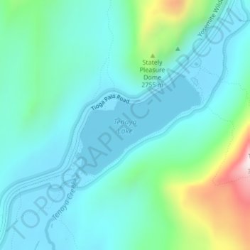
Name: Tenaya Lake topographic map, elevation, terrain.
Location: Tenaya Lake, Mariposa County, California, United States (37.82571 -119.46821 37.83649 -119.45109)
Average elevation: 8,547 ft
Minimum elevation: 8,153 ft
Maximum elevation: 10,144 ft
Mariposa County trails, hiking, mountain biking, running and outdoor activities
Make a donation
Gear up for your next adventure:
As an Amazon Associate, this site earns from qualifying purchases at no extra cost to you.
Other topographic maps
Click on a map to view its topography, its elevation and its terrain.
Mariposa
United States > California > Mariposa County
Mariposa is located at 37°29′06″N 119°57′59″W / 37.48500°N 119.96639°W / 37.48500; -119.96639, at 1,949 feet (594 m) in elevation. It lies in the rugged foothills of the Sierra Nevada. Mariposa Creek flows through the town. Soils in the urban area are mostly brown to reddish brown loam of…
Average elevation: 2,257 ft
Glacier Point
United States > California > Mariposa County > Curry Village
Glacier Point is a viewpoint above Yosemite Valley in the U.S. state of California. It is located on the south wall of Yosemite Valley at an elevation of 7,214 feet (2,199 m), 3,200 feet (980 m) above Curry Village. The point offers a superb view of several of Yosemite National Park's well-known landmarks,…
Average elevation: 5,614 ft
Yosemite Valley
United States > California > Mariposa County > Yosemite Village > Yosemite Lodge
Average elevation: 4,852 ft
Make a donation
Gear up for your next adventure:
As an Amazon Associate, this site earns from qualifying purchases at no extra cost to you.
Falls View
United States > California > Mariposa County > Yosemite Village > Yosemite Lodge
Average elevation: 5,046 ft
Glacier Point
United States > California > Mariposa County > Curry Village
Glacier Point is a viewpoint above Yosemite Valley in the U.S. state of California. It is located on the south wall of Yosemite Valley at an elevation of 7,214 feet (2,199 m), 3,200 feet (980 m) above Curry Village. The point offers a superb view of several of Yosemite National Park's well-known landmarks,…
Average elevation: 5,823 ft
Make a donation
Gear up for your next adventure:
As an Amazon Associate, this site earns from qualifying purchases at no extra cost to you.
Make a donation
Gear up for your next adventure:
As an Amazon Associate, this site earns from qualifying purchases at no extra cost to you.
Make a donation
Gear up for your next adventure:
As an Amazon Associate, this site earns from qualifying purchases at no extra cost to you.