
Lianyungang topographic map
Interactive map
Click on the map to display elevation.
About this map
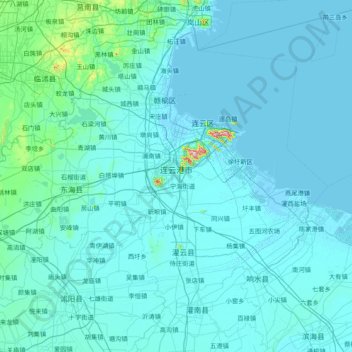
Name: Lianyungang topographic map, elevation, terrain.
Location: Lianyungang, Jiangsu, Chine (33.98548 118.39555 35.15528 119.94289)
Average elevation: 59 ft
Minimum elevation: -10 ft
Maximum elevation: 1,900 ft
Other topographic maps
Click on a map to view its topography, its elevation and its terrain.
District de Sucheng
District de Sucheng, Suqian, Jiangsu, Chine
Average elevation: 69 ft
Lianyungang
Chine > Jiangsu > Lianyungang
Lianyungang, 海州区 (Haizhou), 连云港市, Jiangsu, Chine
Average elevation: 56 ft