
Fanteakwa South District topographic map
Interactive map
Click on the map to display elevation.
About this map
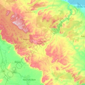
Name: Fanteakwa South District topographic map, elevation, terrain.
Location: Fanteakwa South District, Eastern Region, Ghana (6.26340 -0.54743 6.47883 -0.20481)
Average elevation: 1,257 ft
Minimum elevation: 236 ft
Maximum elevation: 2,592 ft
Other topographic maps
Click on a map to view its topography, its elevation and its terrain.
Akim Oda
Ghana > Eastern Region > Birim Central Municipal District
Akim Oda, Birim Central Municipal District, Eastern Region, Ghana
Average elevation: 420 ft
New Juaben South Municipal District
New Juaben South Municipal District, Eastern Region, Ghana
Average elevation: 682 ft
Koforidua
Ghana > Eastern Region > New Juaben South Municipal District
Koforidua, New Juaben South Municipal District, Eastern Region, Ghana
Average elevation: 719 ft
Nsutam
Ghana > Eastern Region > Fanteakwa South District
Nsutam, Fanteakwa South District, Eastern Region, Ghana
Average elevation: 682 ft
Asokore
Ghana > Eastern Region > New Juaben North Municipal District
Asokore, New Juaben North Municipal District, Eastern Region, Ghana
Average elevation: 794 ft
Kitase
Ghana > Eastern Region > Akuapim South District
Kitase, Akuapim South District, Eastern Region, Ghana
Average elevation: 974 ft
Berekuso
Ghana > Eastern Region > Akuapim South District
Berekuso, Akuapim South District, Eastern Region, Ghana
Average elevation: 738 ft
Fanteakwa North District
Fanteakwa North District, Eastern Region, Ghana
Average elevation: 1,119 ft
Kwahu Kotoso
Ghana > Eastern Region > Kwahu Kotoso
Kwahu Kotoso, Eastern Region, Ghana
Average elevation: 469 ft
Kwahu South District
Kwahu South District, Eastern Region, Ghana
Average elevation: 899 ft
Apaso
Ghana > Eastern Region > Asuogyaman District > Apaso
Apaso, Asuogyaman District, Eastern Region, Ghana
Average elevation: 194 ft