
Make a donation
Gear up for your next adventure:
As an Amazon Associate, this site earns from qualifying purchases at no extra cost to you.
Gosbach topographic map
Click on the map to display elevation.
Make a donation
Gear up for your next adventure:
As an Amazon Associate, this site earns from qualifying purchases at no extra cost to you.
About this map
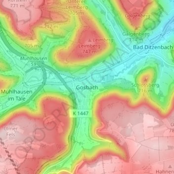
Name: Gosbach topographic map, elevation, terrain.
Average elevation: 2,133 ft
Minimum elevation: 1,631 ft
Maximum elevation: 2,589 ft
Make a donation
Gear up for your next adventure:
As an Amazon Associate, this site earns from qualifying purchases at no extra cost to you.
Other topographic maps
Click on a map to view its topography, its elevation and its terrain.
73312
Germany > Baden-Württemberg > Landkreis Göppingen > Geislingen an der Steige > Weiler ob Helfenstein
Average elevation: 2,018 ft
Ottenbach
Germany > Baden-Württemberg > Landkreis Göppingen
Cycling: Nationally known is Ottenbach for the organization and conduct of mass sports bike marathon "Alb-extreme". The itinerary leads annually on the last Sunday in June over a distance of 190, 210 and 260 km through the countryside of the Swabian Jura with many elevations.
Average elevation: 1,473 ft
Make a donation
Gear up for your next adventure:
As an Amazon Associate, this site earns from qualifying purchases at no extra cost to you.
Geislingen an der Steige
Germany > Baden-Württemberg > Landkreis Göppingen
The importance of the Rorgensteig church for the religious life of the Geislingen community decreased since the elevation of the Geislingen Lady Chapel to a parish church (around 1393) and the construction of the present town church in the years 1424 to 1428. Rorgensteig with its mills had special significance…
Average elevation: 2,008 ft
Hohenstadt
Germany > Baden-Württemberg > Landkreis Göppingen
The municipality (Gemeinde) of Hohenstadt is situated in the district of Göppingen, of the German state of Baden-Württemberg. Hohenstadt lies at the southernmost tip of Göppingen's district, along its border with the Alb-Danube district. The municipal area is physically located in the Middle Kuppenalb [de].…
Average elevation: 2,543 ft
Eislingen/Fils
Germany > Baden-Württemberg > Landkreis Göppingen
The city (Stadt) of Eislingen is located in the north of the district of Göppingen, in the German state of Baden-Württemberg. Eislingen is physically located in the Fils river valley, at the mouth of the Krumm, in the central [de] and eastern foothills [de] of the Swabian Jura. Elevation above sea level in…
Average elevation: 1,211 ft
Make a donation
Gear up for your next adventure:
As an Amazon Associate, this site earns from qualifying purchases at no extra cost to you.
Deggingen
Germany > Baden-Württemberg > Landkreis Göppingen > Deggingen
The municipality (Gemeinde) of Deggingen is found in the district of Göppingen, in Baden-Württemberg, one of the 16 States of the Federal Republic of Germany. Deggingen is physically located in the upper Fils river valley, in the Filsalb region of the Middle Kuppenalb . Elevation above sea level in the…
Average elevation: 2,110 ft
Donzdorf
Germany > Baden-Württemberg > Landkreis Göppingen
Donzdorf is located in the valley of the river Lauter, a tributary of the Fils river, 12 km east of Göppingen, on an elevation between 334 and 749 metres.
Average elevation: 1,726 ft
Geislingen an der Steige
Germany > Baden-Württemberg > Landkreis Göppingen
The importance of the Rorgensteig church for the religious life of the Geislingen community decreased since the elevation of the Geislingen Lady Chapel to a parish church (around 1393) and the construction of the present town church in the years 1424 to 1428. Rorgensteig with its mills had special significance…
Average elevation: 2,008 ft
Make a donation
Gear up for your next adventure:
As an Amazon Associate, this site earns from qualifying purchases at no extra cost to you.