
Make a donation
Gear up for your next adventure:
As an Amazon Associate, this site earns from qualifying purchases at no extra cost to you.
Donzdorf topographic map
Click on the map to display elevation.
Make a donation
Gear up for your next adventure:
As an Amazon Associate, this site earns from qualifying purchases at no extra cost to you.
Donzdorf
Donzdorf is located in the valley of the river Lauter, a tributary of the Fils river, 12 km east of Göppingen, on an elevation between 334 and 749 metres.
Make a donation
Gear up for your next adventure:
As an Amazon Associate, this site earns from qualifying purchases at no extra cost to you.
About this map
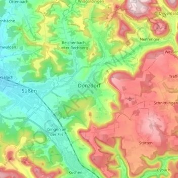
Name: Donzdorf topographic map, elevation, terrain.
Average elevation: 1,726 ft
Minimum elevation: 1,148 ft
Maximum elevation: 2,562 ft
Make a donation
Gear up for your next adventure:
As an Amazon Associate, this site earns from qualifying purchases at no extra cost to you.
Other topographic maps
Click on a map to view its topography, its elevation and its terrain.