Geolocate

Stillwell topographic map

Click on the map to display elevation.

About this map

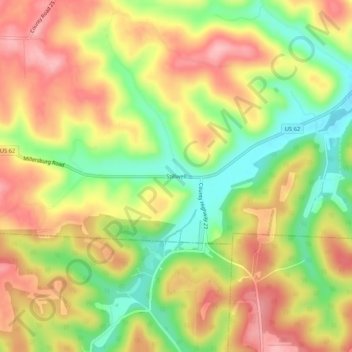
Name: Stillwell topographic map, elevation, terrain.

Location: Stillwell, Holmes County, Ohio, United States (40.44062 -82.11432 40.48062 -82.07432)

Average elevation: 1,073 ft

Minimum elevation: 833 ft

Maximum elevation: 1,286 ft

Holmes County trails, hiking, mountain biking, running and outdoor activities

Other topographic maps

Click on a map to view its topography, its elevation and its terrain.

Lake Buckhorn

United States > Ohio > Holmes County > Clark

Average elevation: 984 ft

Holmesville

United States > Ohio > Holmes County

Average elevation: 860 ft

Nashville

United States > Ohio > Holmes County

Average elevation: 1,191 ft

Gear up for your next adventure:

🧤Tactile Hiking Gloves - Keep hands warm while operating GPS and smartphone screens
📦Gear Storage Bags - Organize and protect outdoor equipment
📱Heavy-Duty Phone Cases - Drop-proof and waterproof protection for outdoor navigation
🧯Portable Fire Pit - Compact fire pit for camping spots
💧Water Purification System - Clean water on the trail with reliable purifiers

As an Amazon Associate, this site earns from qualifying purchases at no extra cost to you.