Geolocate

Nashville topographic map

Click on the map to display elevation.

About this map

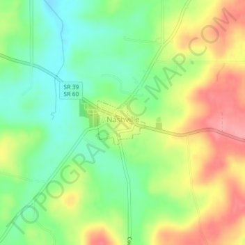
Name: Nashville topographic map, elevation, terrain.

Location: Nashville, Holmes County, Ohio, 44661, United States (40.59340 -82.11579 40.59827 -82.10872)

Average elevation: 1,191 ft

Minimum elevation: 1,047 ft

Maximum elevation: 1,371 ft

Holmes County trails, hiking, mountain biking, running and outdoor activities

Other topographic maps

Click on a map to view its topography, its elevation and its terrain.

Walnut Creek

United States > Ohio > Holmes County

Average elevation: 1,073 ft

Lake Buckhorn

United States > Ohio > Holmes County > Clark

Average elevation: 984 ft

Lakeville

United States > Ohio > Holmes County

Average elevation: 1,024 ft

Stillwell

United States > Ohio > Holmes County

Average elevation: 1,073 ft

Unionville

United States > Ohio > Holmes County

Average elevation: 1,125 ft

Farmerstown

United States > Ohio > Holmes County

Average elevation: 1,112 ft

Big Prairie

United States > Ohio > Holmes County

Average elevation: 1,027 ft

Winesburg

United States > Ohio > Holmes County

Average elevation: 1,175 ft

Mount Hope

United States > Ohio > Holmes County

Average elevation: 1,194 ft

Berlin

United States > Ohio > Holmes County

Average elevation: 1,171 ft

Gear up for your next adventure:

📶Satellite Messenger - Communication device off‑grid
🧢Outdoor Hiking Hat - Sun protection hat for outdoor explorers
🔦Compact Flashlight - Reliable flashlight for emergencies
🧤Hiking Gloves - Protective gloves for rugged trails
🛏️Cold Weather Sleeping Bag - Warm sleeping bag for cold conditions

As an Amazon Associate, this site earns from qualifying purchases at no extra cost to you.