Geolocate

Chure topographic map

Click on the map to display elevation.

About this map

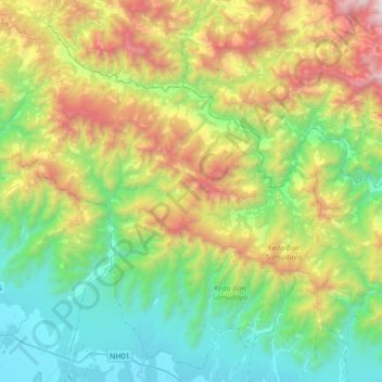
Name: Chure topographic map, elevation, terrain.

Location: Chure, Kailali, Sudurpashchim Province, Nepal (28.78713 80.51731 29.06890 80.86273)

Average elevation: 3,081 ft

Minimum elevation: 604 ft

Maximum elevation: 8,320 ft

Other topographic maps

Click on a map to view its topography, its elevation and its terrain.

Tikapur

Nepal > Sudurpashchim Province > Kailali

Average elevation: 518 ft

Tikapur

Nepal > Sudurpashchim Province > Kailali

Average elevation: 518 ft

Dhami Tol

Nepal > Sudurpashchim Province > Kailali > Banjariya

Average elevation: 482 ft

GETA

Nepal > Sudurpashchim Province > Kailali

Average elevation: 614 ft

Lakkad

Nepal > Sudurpashchim Province > Kailali

Average elevation: 495 ft

Dhangadhi

Nepal > Sudurpashchim Province > Kailali

Average elevation: 633 ft

Gear up for your next adventure:

📡GPS Antenna Upgrade - Enhance GPS reception in remote terrain
🌎3D Topographic Globes - Raised relief globes for a tactile understanding of geography
📚USA Hiking Guide Books - Top trail guides and map books
🔦LED Headlamp - Bright and durable LED headlamp for night navigation
👖Convertible Hiking Pants - Versatile zip-off pants for changing altitudes and temperatures

As an Amazon Associate, this site earns from qualifying purchases at no extra cost to you.