
Make a donation
Gear up for your next adventure:
As an Amazon Associate, this site earns from qualifying purchases at no extra cost to you.
San de Fuca topographic map
Click on the map to display elevation.
Make a donation
Gear up for your next adventure:
As an Amazon Associate, this site earns from qualifying purchases at no extra cost to you.
About this map
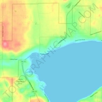
Name: San de Fuca topographic map, elevation, terrain.
Location: San de Fuca, Island County, Washington, United States (48.21510 -122.74323 48.25510 -122.70323)
Average elevation: 102 ft
Minimum elevation: -7 ft
Maximum elevation: 299 ft
Island County trails, hiking, mountain biking, running and outdoor activities
Make a donation
Gear up for your next adventure:
As an Amazon Associate, this site earns from qualifying purchases at no extra cost to you.
Other topographic maps
Click on a map to view its topography, its elevation and its terrain.
Ebey's Landing National Historical Reserve
United States > Washington > Island County
Average elevation: 82 ft
Make a donation
Gear up for your next adventure:
As an Amazon Associate, this site earns from qualifying purchases at no extra cost to you.