Geolocate

西舍路镇 topographic map

Interactive map

Click on the map to display elevation.

About this map

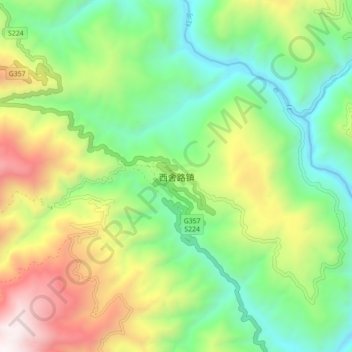
Name: 西舍路镇 topographic map, elevation, terrain.

Location: 西舍路镇, 楚雄市, 楚雄彝族自治州, 云南省, 中国 (24.62868 101.03136 24.70868 101.11136)

Average elevation: 4,977 ft

Minimum elevation: 2,818 ft

Maximum elevation: 8,806 ft

Other topographic maps

Click on a map to view its topography, its elevation and its terrain.

中山镇

中国 > 云南省 > 楚雄市

中山镇, 楚雄市, 楚雄彝族自治州, 云南省, 中国

Average elevation: 7,359 ft

苍岭镇

中国 > 云南省 > 楚雄市

苍岭镇, 楚雄市, 楚雄彝族自治州, 云南省, 中国

Average elevation: 6,181 ft

三街镇

中国 > 云南省 > 楚雄市

三街镇, 楚雄市, 楚雄彝族自治州, 云南省, 中国

Average elevation: 6,572 ft

峨碌公园

中国 > 云南省 > 楚雄市 > 鹿城镇

峨碌公园, 鹿城镇, 楚雄市, 楚雄彝族自治州, 云南省, 中国

Average elevation: 6,053 ft

紫溪镇

中国 > 云南省 > 楚雄市

紫溪镇, 楚雄市, 楚雄彝族自治州, 云南省, 中国

Average elevation: 6,240 ft

楚雄州

中国 > 云南省 > 楚雄市

楚雄州, 楚雄市, 楚雄彝族自治州, 云南省, 中国

Average elevation: 6,253 ft

子午镇

中国 > 云南省 > 楚雄市 > 子午镇

子午镇, 楚雄市, 楚雄彝族自治州, 云南省, 中国

Average elevation: 6,293 ft

树苴乡

中国 > 云南省 > 楚雄市 > 树苴乡

树苴乡, 楚雄市, 楚雄彝族自治州, 云南省, 中国

Average elevation: 6,877 ft