
Make a donation
Gear up for your next adventure:
As an Amazon Associate, this site earns from qualifying purchases at no extra cost to you.
Ascheberg topographic map
Click on the map to display elevation.
Make a donation
Gear up for your next adventure:
As an Amazon Associate, this site earns from qualifying purchases at no extra cost to you.
About this map
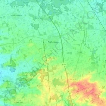
Name: Ascheberg topographic map, elevation, terrain.
Average elevation: 233 ft
Minimum elevation: 174 ft
Maximum elevation: 384 ft
Make a donation
Gear up for your next adventure:
As an Amazon Associate, this site earns from qualifying purchases at no extra cost to you.
Other topographic maps
Click on a map to view its topography, its elevation and its terrain.
Dülmen
Deutschland > Nordrhein-Westfalen > Kreis Coesfeld
Der zügige Wiederaufbau der Wohn- und Arbeitsstätten erreichte bei der Übergabe des neuen Rathauses 1956 einen festlich begangenen Höhepunkt. Dülmen schloss mit der nahe Charleville gelegenen französischen Stadt Mézières 1963 eine Partnerschaft. Durch die Stationierung des Artillerieregiments 7 der…
Average elevation: 220 ft
Make a donation
Gear up for your next adventure:
As an Amazon Associate, this site earns from qualifying purchases at no extra cost to you.
Make a donation
Gear up for your next adventure:
As an Amazon Associate, this site earns from qualifying purchases at no extra cost to you.
Seppenrade
Deutschland > Nordrhein-Westfalen > Kreis Coesfeld > Lüdinghausen
Average elevation: 262 ft
Make a donation
Gear up for your next adventure:
As an Amazon Associate, this site earns from qualifying purchases at no extra cost to you.
Limbergen
Deutschland > Nordrhein-Westfalen > Kreis Coesfeld > Dülmen > Buldern
Average elevation: 249 ft
Make a donation
Gear up for your next adventure:
As an Amazon Associate, this site earns from qualifying purchases at no extra cost to you.
Billerbecker Berg
Deutschland > Nordrhein-Westfalen > Kreis Coesfeld > Billerbeck
Average elevation: 489 ft
Make a donation
Gear up for your next adventure:
As an Amazon Associate, this site earns from qualifying purchases at no extra cost to you.
Waldferiensiedlung Eversum
Deutschland > Nordrhein-Westfalen > Kreis Coesfeld > Olfen > Waldferiensiedlung Eversum
Average elevation: 157 ft