
Make a donation
Gear up for your next adventure:
As an Amazon Associate, this site earns from qualifying purchases at no extra cost to you.
Karun Kuh group topographic map
Click on the map to display elevation.
Make a donation
Gear up for your next adventure:
As an Amazon Associate, this site earns from qualifying purchases at no extra cost to you.
About this map
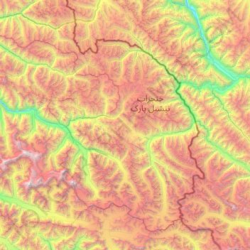
Name: Karun Kuh group topographic map, elevation, terrain.
Location: Karun Kuh group, Gilgit-Baltistan, Pakistan (36.07491 74.79084 36.79432 76.01822)
Average elevation: 16,020 ft
Minimum elevation: 8,976 ft
Maximum elevation: 25,443 ft
Make a donation
Gear up for your next adventure:
As an Amazon Associate, this site earns from qualifying purchases at no extra cost to you.
Other topographic maps
Click on a map to view its topography, its elevation and its terrain.
360 views of Rakaposhi and Hunza
Pakistan > Gilgit-Baltistan > Nagar District
Average elevation: 11,391 ft
Make a donation
Gear up for your next adventure:
As an Amazon Associate, this site earns from qualifying purchases at no extra cost to you.
Chilum
Pakistan > Gilgit-Baltistan > Astore District
Chilum or Chilam is a village of Astore District in Gilgit-Baltistan, Pakistan. It is located near the junction of the Deosai Road and the Astore–Srinagar road. There is checkpost nearby, referred to as Chilam Chowki, at 35°2'8"N 75°6'10" E and elevation 3869 m (12696 ft).
Average elevation: 12,146 ft
Make a donation
Gear up for your next adventure:
As an Amazon Associate, this site earns from qualifying purchases at no extra cost to you.