
Make a donation
Gear up for your next adventure:
As an Amazon Associate, this site earns from qualifying purchases at no extra cost to you.
Hazlet Township topographic map
Click on the map to display elevation.
Make a donation
Gear up for your next adventure:
As an Amazon Associate, this site earns from qualifying purchases at no extra cost to you.
About this map
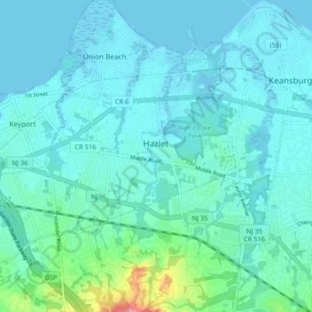
Name: Hazlet Township topographic map, elevation, terrain.
Average elevation: 49 ft
Minimum elevation: -7 ft
Maximum elevation: 351 ft
Monmouth County trails, hiking, mountain biking, running and outdoor activities
Make a donation
Gear up for your next adventure:
As an Amazon Associate, this site earns from qualifying purchases at no extra cost to you.
Other topographic maps
Click on a map to view its topography, its elevation and its terrain.
Freneau Woods Park
United States > New Jersey > Monmouth County > Aberdeen Township > Henningers Mill
Average elevation: 75 ft
Make a donation
Gear up for your next adventure:
As an Amazon Associate, this site earns from qualifying purchases at no extra cost to you.
Burlington Heights
United States > New Jersey > Monmouth County > Freehold Township
Average elevation: 154 ft
Make a donation
Gear up for your next adventure:
As an Amazon Associate, this site earns from qualifying purchases at no extra cost to you.
Hendrickson Corners
United States > New Jersey > Monmouth County > Middletown Township
Average elevation: 72 ft
Van Marters Corner
United States > New Jersey > Monmouth County > Hazlet Township
Average elevation: 20 ft
Homes Mills
United States > New Jersey > Monmouth County > Upper Freehold Township
Average elevation: 112 ft
Make a donation
Gear up for your next adventure:
As an Amazon Associate, this site earns from qualifying purchases at no extra cost to you.
Robinsville
United States > New Jersey > Monmouth County > Upper Freehold Township
Average elevation: 184 ft
Echo Lake Park
United States > New Jersey > Monmouth County > Howell Township
Average elevation: 85 ft
Make a donation
Gear up for your next adventure:
As an Amazon Associate, this site earns from qualifying purchases at no extra cost to you.
Bucks Mill
United States > New Jersey > Monmouth County > Colts Neck Township
Average elevation: 112 ft
Make a donation
Gear up for your next adventure:
As an Amazon Associate, this site earns from qualifying purchases at no extra cost to you.
Make a donation
Gear up for your next adventure:
As an Amazon Associate, this site earns from qualifying purchases at no extra cost to you.
West Keansburg
United States > New Jersey > Monmouth County > Hazlet Township
Average elevation: 13 ft
Emleys Hill
United States > New Jersey > Monmouth County > Upper Freehold Township
Average elevation: 151 ft
Make a donation
Gear up for your next adventure:
As an Amazon Associate, this site earns from qualifying purchases at no extra cost to you.
Hendrickson Corners
United States > New Jersey > Monmouth County > Middletown Township
Average elevation: 72 ft
Freewood Acres
United States > New Jersey > Monmouth County > Howell Township
Average elevation: 121 ft
Make a donation
Gear up for your next adventure:
As an Amazon Associate, this site earns from qualifying purchases at no extra cost to you.
Morganville
United States > New Jersey > Monmouth County > Marlboro Township
Average elevation: 141 ft
Villa Park
United States > New Jersey > Monmouth County > Spring Lake Heights
Average elevation: 26 ft
Make a donation
Gear up for your next adventure:
As an Amazon Associate, this site earns from qualifying purchases at no extra cost to you.
Hendrickson Corners
United States > New Jersey > Monmouth County > Middletown Township
Average elevation: 72 ft
Town Brook
United States > New Jersey > Monmouth County > Middletown Township
Average elevation: 89 ft
Make a donation
Gear up for your next adventure:
As an Amazon Associate, this site earns from qualifying purchases at no extra cost to you.
New Monmouth
United States > New Jersey > Monmouth County > Middletown Township
Average elevation: 49 ft
Freehold
United States > New Jersey > Monmouth County > Freehold Borough > Freehold
Freehold has an elevation of 174 feet (53 m) above sea level at its center.
Average elevation: 148 ft
Make a donation
Gear up for your next adventure:
As an Amazon Associate, this site earns from qualifying purchases at no extra cost to you.
Bradley Park
United States > New Jersey > Monmouth County > Neptune > Bradley Park
Average elevation: 23 ft
Port-au-Peck
United States > New Jersey > Monmouth County > Oceanport > Port-au-Peck
Average elevation: 13 ft
Make a donation
Gear up for your next adventure:
As an Amazon Associate, this site earns from qualifying purchases at no extra cost to you.
Collingwood Park
United States > New Jersey > Monmouth County > Collingwood Park
Average elevation: 102 ft
Carrs Tavern
United States > New Jersey > Monmouth County > Millstone Township > Carrs Tavern
Average elevation: 174 ft
Make a donation
Gear up for your next adventure:
As an Amazon Associate, this site earns from qualifying purchases at no extra cost to you.