
Florence topographic map
Click on the map to display elevation.
About this map
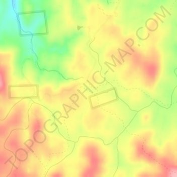
Name: Florence topographic map, elevation, terrain.
Location: Florence, Idaho County, Idaho, United States (45.49101 -116.03847 45.51101 -116.01847)
Average elevation: 6,089 ft
Minimum elevation: 5,850 ft
Maximum elevation: 6,260 ft
Idaho County trails, hiking, mountain biking, running and outdoor activities
Other topographic maps
Click on a map to view its topography, its elevation and its terrain.
Ferdinand
United States > Idaho > Idaho County
Ferdinand is located at 46°9′10″N 116°23′26″W / 46.15278°N 116.39056°W / 46.15278; -116.39056 (46.152701, -116.390438), at an elevation of 3,720 feet (1,130 m) above sea level on the Camas Prairie.
Average elevation: 3,766 ft
Kooskia
United States > Idaho > Idaho County
Kooskia is located at 46°8′30″N 115°58′47″W / 46.14167°N 115.97972°W / 46.14167; -115.97972 (46.139, -115.979), at an elevation of 1,293 feet (394 m) [above sea level.
Average elevation: 1,506 ft