
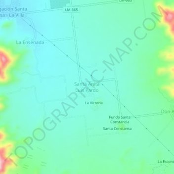
Santa Anita Luis Pardo topographic map
Interactive map
Click on the map to display elevation.
About this map
Name: Santa Anita Luis Pardo topographic map, elevation, terrain.
Location: Santa Anita Luis Pardo, Sayán, Huaura, Lima, Perú (-11.27146 -77.38052 -11.23146 -77.34052)
Average elevation: 1,434 ft
Minimum elevation: 1,280 ft
Maximum elevation: 2,031 ft
Other topographic maps
Click on a map to view its topography, its elevation and its terrain.
Irrigación Santa Rosa - La Villa
Irrigación Santa Rosa - La Villa, Sayán, Huaura, Lima, Perú
Average elevation: 1,339 ft
Provincia de Huaura
Provincia de Huaura, Sayán, Huaura, Lima, Perú
Average elevation: 2,874 ft