
章子峰 topographic map
Interactive map
Click on the map to display elevation.
About this map
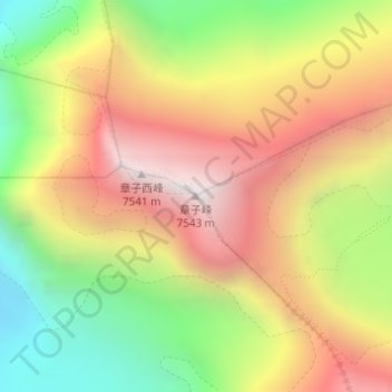
Name: 章子峰 topographic map, elevation, terrain.
Location: 章子峰, 扎西宗, 定日县, 日喀则市, 西藏自治区, 中国 (28.02428 86.91514 28.02438 86.91524)
Average elevation: 22,198 ft
Minimum elevation: 19,669 ft
Maximum elevation: 24,616 ft
章子峰是西藏的山峰,位於喜馬拉雅山脈,處於珠穆朗瑪峰以北,海拔高度7,543米,是全球第45高山峰,西德攀山隊在1982年10月3日首次登上該山峰。
Other topographic maps
Click on a map to view its topography, its elevation and its terrain.
Lapche Kang III
Lapche Kang III, 扎西宗, 定日县, 日喀则市, 西藏自治区, 中国
Average elevation: 21,322 ft