
Khartaphu topographic map
Interactive map
Click on the map to display elevation.
About this map
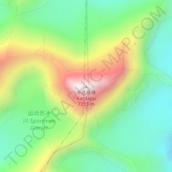
Name: Khartaphu topographic map, elevation, terrain.
Location: Khartaphu, 扎西宗, 定日县, 日喀则市, 西藏自治区, 中国 (28.06413 86.97724 28.06423 86.97734)
Average elevation: 21,693 ft
Minimum elevation: 20,581 ft
Maximum elevation: 23,589 ft
Other topographic maps
Click on a map to view its topography, its elevation and its terrain.
Lapche Kang III
Lapche Kang III, 扎西宗, 定日县, 日喀则市, 西藏自治区, 中国
Average elevation: 21,322 ft