
Make a donation
Gear up for your next adventure:
As an Amazon Associate, this site earns from qualifying purchases at no extra cost to you.
Big Spring topographic map
Click on the map to display elevation.
Make a donation
Gear up for your next adventure:
As an Amazon Associate, this site earns from qualifying purchases at no extra cost to you.
About this map
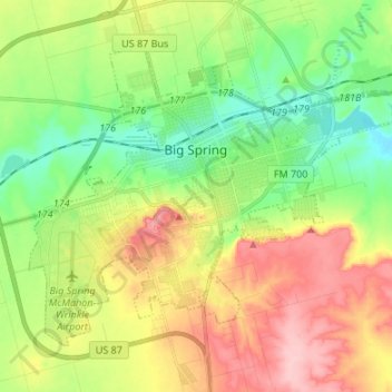
Name: Big Spring topographic map, elevation, terrain.
Location: Big Spring, Howard County, Texas, 79720, United States (32.19339 -101.53611 32.28066 -101.40186)
Average elevation: 2,562 ft
Minimum elevation: 2,359 ft
Maximum elevation: 2,844 ft
Howard County trails, hiking, mountain biking, running and outdoor activities
Make a donation
Gear up for your next adventure:
As an Amazon Associate, this site earns from qualifying purchases at no extra cost to you.
Other topographic maps
Click on a map to view its topography, its elevation and its terrain.
Elbow
United States > Texas > Howard County
The elevation is 2,549 feet (777 m).
Average elevation: 2,556 ft